Alameda Creek Sediment Removal
Home » Get Involved » Neighborhood Zones » Zone 5 » Alameda Creek Watershed & Fish Ladder » Alameda Creek Sediment Removal
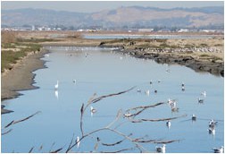
The Alameda Creek Watershed is the largest watershed that drains to San Francisco Bay. At almost 700 square miles, it can generate an enormous amount of stormwater runoff and sediment—particles of sand, dirt, and other material.In the early 1970s, the Army Corps of Engineers constructed the Alameda Creek Federal Flood Control Channel to protect properties in Hayward, Union City, Newark, and Fremont from flooding. In doing so, the channel has been confined between levees that have altered sediment transport.Today, the lower (downstream) seven miles of Alameda Creek experience significant sediment accumulation. The lowest four miles (starting from the bay) are tidally influenced, and the sediment is probably of tidal origin. The next three miles (upstream of the lowest four miles) accumulate sediment from the upper watershed. This three-mile section has been dredged to remove silt—known as desilting—several times since the channel was constructed. Desilting is very expensive.
A Tidal Solution to Solve Part of the Problem
A partial solution to sediment buildup along the lower four miles of Alameda Creek near the bay is tied to the South Bay Salt Pond Restoration Project. The District is helping to restore approximately 5,500 acres of Eden Landing salt ponds along the shorelines of Hayward, Fremont, and Union City.Levees will be removed from the lower reach of Alameda Creek near San Francisco Bay to help create a new wetlands area. When the levees are removed, bay tides will flow in and out of the lower segment of Alameda Creek and flush out—or “scour”—sediment from the creek. This will significantly increase the channel’s ability to carry stormwater. It will also save millions of dollars in dredging costs and environmental mitigation that it would otherwise incur to remove sediment deposits.
 Skip to content